Often said to be the “backbone of England”, The Pennines form an unbroken mountain range stretching from the Peak District, through the Yorkshire Dales and to the Cheviot Hills on the Scottish border. However, this circular route of High Cup Nick, a dramatic glaciated valley sometimes described as “England’s Grand Canyon, will give you a fabulous taste for The Pennines. At 13km, the route is a nice distance for a day hike with an element of challenge on one steep section before traversing the top of the valley and heading for the dramatic viewpoint of Murton Pike. Get the full guide and download the map routes here.

😮Difficulty: moderate – one steep incline and challenging section to the top of High Cup Nick. Paths are well maintained and easy to follow
⛰️Terrain: a mix of good paths and one scrambly, rocky section
↔️Distance: 13.2km/8.2miles
⌛Time taken: 4-5 hours
📈Ascent: 552m
Starting point: Murton Fell Car Park (CA16 6ND)
🗺️Click here for the OS downloadable route.
🗺️Map needed is OS Explorer Map OL19
🗺️Click here for the Komoot downloadable route
Car parking for High Cup Nick
There is a small car park in Murton at the end of the road at the base of Murton Pike. At the time of writing (March 2025) this was free. There are information boards up about the MOD training land, public footpaths, danger zones and access land in the area.
Public Transport to High Cup Nick
Nearby Appleby-in-Westmorland has a train station and is approximately 4 miles from the village of Murton. You could then use a local taxi service to take you to Murton.
High Cup Nick walk route
The first section is a short road walk towards the bend in the road where on your right is a public footpath sign crossing a wall and then a stile, following the well-trodden footpath through the field towards the farm buildings. After following the footpath through the farm, you’ll find yourself in the valley of High Cup Nick and one of the most stunning parts of the walk.
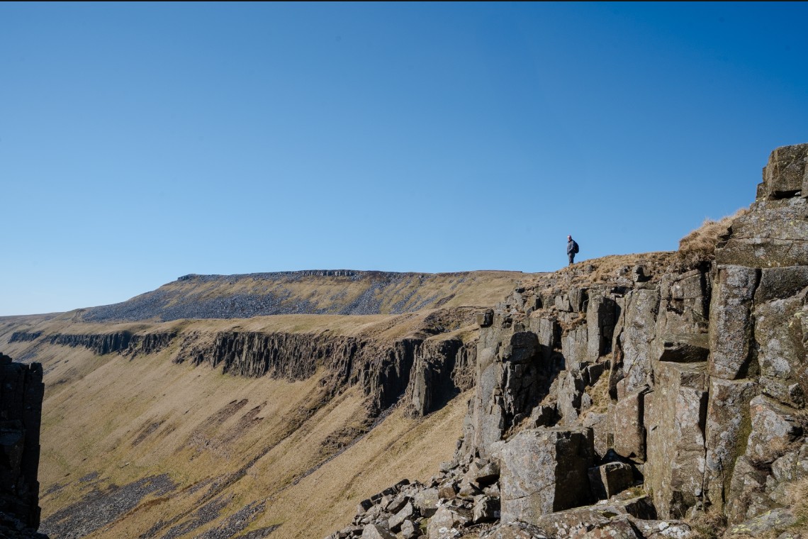
The valley of High Cup Nick is a glaciated U-bend shaped glacial valley, formed by large ice sheet. The path follows a direct route straight up the valley floor but there is also a slightly higher, narrow sheep path to the right. As you follow the path up the valley, you’re surrounded by steep cliffs, large landslides, rock pinnacles, waterfalls (after some rain) and directly in front of you, is the large boulder field and what looks like an inaccessible (and steep) route onto the top.

After passing through a boulder field section caused by landslips, the path starts to rise steeply. This marks the start of the most challenging section, a steep path, becoming loose scree and a final little scramble onto the top.

High Cup Nick
At the top of High Cup Nick, you’ll be rewarded with the most stunning of views down the valley which you’ve just walked up. If there’s anyone down in the valley below, you’ll get a great sense of scale here and a head for heights is definitely needed if you stand close to the edge! The top of High Cup Nick is open to the elements and on a windy day, you’ll soon find yourself getting battered by the gusts. There isn’t much in the way of shelter so wrap up from the wind and for a good lunch spot, head to the right at the top and drop down just as you cross the little stream and sit in amongst the rocks for a snack.

When you’re ready to move on, follow the lower path along the left side of High Cup Nick as you look down the valley. The drops here are huge so be careful of not straying too close to the edge. The path is easy to follow and eventually you’ll meet a stile at a wall. Don’t cross here and instead turn left, following the wall up to the pile of stones high on the shelf above you.

From the pile of stones, keep following the path as it nears a farm wall before veering off, down and across a small beck and then joining the main path leading back down to the direction of the little village of Murton. There are some signposts pointing you in the right direction but be sure to download the route onto your phone and take a map with you because it is easy to go the wrong way. This is particularly important because you’ll now be getting close to Ministry of Defence owned land, regularly used for training with a clear danger zone mapped out you can’t go into unless it’s certain days of the year. Read more about this at the end of the blog.

Murton Pike
You’ll soon join a stony track which leads all the way back down to Murton and in front of you, you’ll see Murton Pike; a grassy hill that sticks out on it’s own, dominating the view in front of you. The path winds its way downhill until you reach the base of the path leading to the summit of Murton Pike. Follow the obvious path to the right leading to the summit. This bit is steep but it’s a short section and the views from the 594m summit are spectacular.

From the summit of Murton Pike, follow your route back to the main path and follow it all the way to the car park in Murton. To your left on the descent you’ll see some disused mine workings and you’re also quite likely to hear some distant shooting from nearby MOD training.
High Cup Nick route on the Ordnance Survey App
Click here to download the route

What do I need to know about the danger area and Ministry of Defence training ground nearby?
Depending on which way you arrive to Murton, you might have already found yourself driving along the single track road through the military training area, through barriers which are sometimes closed and past warning signs and red flags alerting you to the fact you’re in a military training zone.
On arrival at the car park in Murton, you’ll find an information board explaining clearly which areas on the fells you can access safely and which parts are restricted. The danger zone is clearly marked on the Ordnance Survey map for this area too.
This is Warcop Training Area, one of the MOD’s largest army training areas in the UK. It is used 6 ½ days a week for training.
The restricted and so called “danger zone”, lies to the east of Murton Fell and although this walk doesn’t go near here, without some form of navigation it would be very easy to wander too far off route. Therefore, it’s really important to download and look at the route before you set off.
The danger zone is marked with warning signs and if you’re really nosy (like me) they do actually open up the land (although strictly on the permissive footpaths due to unexploded ordnance) on short notice days.
Take a look at this map which clearly shows the danger zone
